iFANN
    ابحث في iFANN...
    تسجيل الدخول
    الرئيسية
    الأخبار
    فيديوهات
    صور
    صور GIF
    استكشاف
    استطلاعات
    الجوائز
    iFAMOUS
    ويكي
    أنمي
    غرف
    الإشعارات
    الرسائل
    المحفوظات
    الملف الشخصي
    ويكيالجوائزiFAMOUSالتصنيفاتالقطاعاتمكافآت المبدعينمكافآت المستخدمينالشروطالخصوصيةإرشادات المجتمعالإزالة / DMCAالمساعدةالمطورون

    © 2026 iFANN

    الرئيسية
    بحث
    الرسائل
    التنبيهات
    الملف الشخصي
    صورة
    Jolyon
    Jolyon@jolyon3w
    💭News💭Politics
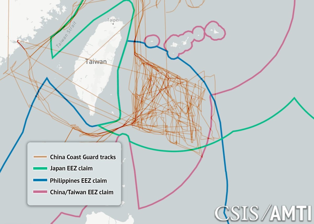
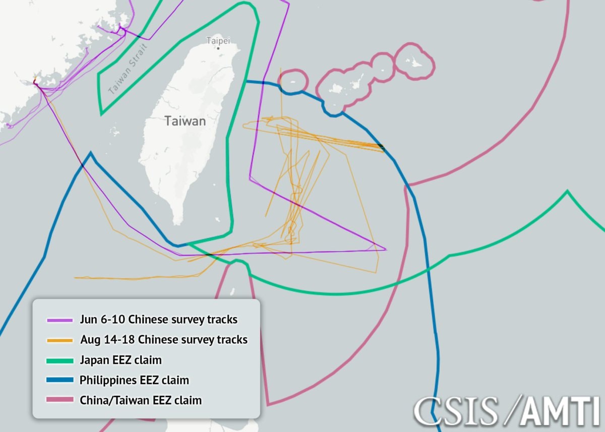
    China Coast Guard tracks east of Taiwan (photo 1 of 3)
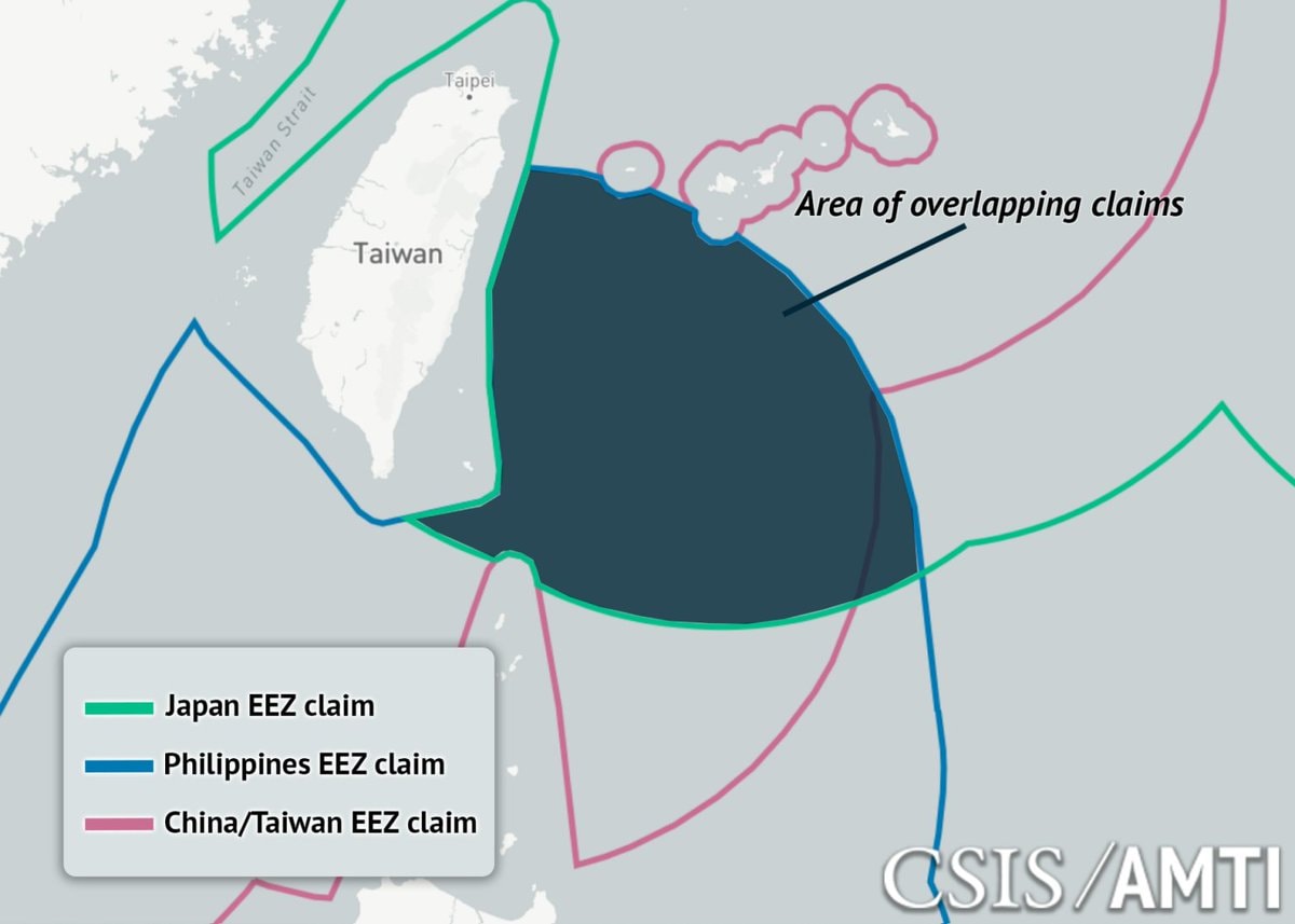
    China Coast Guard tracks east of Taiwan (photo 2 of 3)
    China Coast Guard tracks east of Taiwan (photo 3 of 3)

    @jolyonChina's coast guard intercepted 198 commercial vessels east of Taiwan, demanding crew rosters and destination ports. This escalation followed Japan and the Philippines announcing boundary talks in May to resolve overlapping claims between the Ryukyus and the Batanes. Beijing declared those discussions null and void before deploying survey ships, 10,000-ton patrol boats, and coast guard hulls that have held station since June. Interrogating merchant traffic posing no threat to seabed resources exceeds enforcement rights under UNCLOS, even within a coastal state's own zone. Most surveying occurred within 50 miles of Taiwan, far from the actual boundary line. Since these talks typically span years, the source suggests this pattern mirrors a rehearsal for quarantining Taiwan. Visual data from CSIS/AMTI tracks these movements on a map showing EEZ claims across the region.

    عرض المنشور الأصلي
    China Coast Guard tracks east of Taiwan

    صورة بواسطة @jolyon· Aug 22, 2026· صورة 1 من 3· News

    عن هذه الصورة

    The image is a map showing maritime boundaries and ship tracks in the waters around Taiwan. It displays the Taiwan Strait, Taiwan itself, and surrounding EEZ claims from Japan, the Philippines, and China/Taiwan. Numerous orange lines, labeled "China Coast Guard tracks," crisscross the waters, particularly east of Taiwan. The overall style is informational and data-driven, with a watermark in the lower right corner reading "CSIS/AMTI."

    عرض كل صور News

    ?

    لا توجد تعليقات بعد. كن أول من يعلّق!

    المزيد من صور News

    عرض كل صور News
    Cartrack customer data breach confirmedCartrack customer data breach confirmedUS Strategic Petroleum Reserve lowest since 19823US Strategic Petroleum Reserve lowest since 1982Ella Langley Tate McRae new photoElla Langley Tate McRae new photoLebanon displacement data September 93Lebanon displacement data September 9Countries ranked by average mood scoreCountries ranked by average mood scoreKojima Productions Xbox partnershipKojima Productions Xbox partnershipTrump on Iran and dieselTrump on Iran and dieselXbox CEO Asha SharmaXbox CEO Asha SharmaTom Holland highest grossing actor2Tom Holland highest grossing actorRoblox top creators earningsRoblox top creators earningsI'm single and searching 😔I'm single and searching 😔
    صورة
    Jolyon
    Jolyon@jolyon3w
    💭News💭Politics
    China Coast Guard tracks east of Taiwan (photo 1 of 3)
    China Coast Guard tracks east of Taiwan (photo 2 of 3)
    China Coast Guard tracks east of Taiwan (photo 3 of 3)

    @jolyonChina's coast guard intercepted 198 commercial vessels east of Taiwan, demanding crew rosters and destination ports. This escalation followed Japan and the Philippines announcing boundary talks in May to resolve overlapping claims between the Ryukyus and the Batanes. Beijing declared those discussions null and void before deploying survey ships, 10,000-ton patrol boats, and coast guard hulls that have held station since June. Interrogating merchant traffic posing no threat to seabed resources exceeds enforcement rights under UNCLOS, even within a coastal state's own zone. Most surveying occurred within 50 miles of Taiwan, far from the actual boundary line. Since these talks typically span years, the source suggests this pattern mirrors a rehearsal for quarantining Taiwan. Visual data from CSIS/AMTI tracks these movements on a map showing EEZ claims across the region.

    عرض المنشور الأصلي

    China Coast Guard tracks east of Taiwan

    صورة بواسطة @jolyon· Aug 22, 2026· صورة 1 من 3· News

    عن هذه الصورة

    The image is a map showing maritime boundaries and ship tracks in the waters around Taiwan. It displays the Taiwan Strait, Taiwan itself, and surrounding EEZ claims from Japan, the Philippines, and China/Taiwan. Numerous orange lines, labeled "China Coast Guard tracks," crisscross the waters, particularly east of Taiwan. The overall style is informational and data-driven, with a watermark in the lower right corner reading "CSIS/AMTI."

    عرض كل صور News

    ?

    لا توجد تعليقات بعد. كن أول من يعلّق!

    المزيد من صور News

    عرض كل صور News
    Cartrack customer data breach confirmedCartrack customer data breach confirmedUS Strategic Petroleum Reserve lowest since 19823US Strategic Petroleum Reserve lowest since 1982Ella Langley Tate McRae new photoElla Langley Tate McRae new photoLebanon displacement data September 93Lebanon displacement data September 9Countries ranked by average mood scoreCountries ranked by average mood scoreKojima Productions Xbox partnershipKojima Productions Xbox partnershipTrump on Iran and dieselTrump on Iran and dieselXbox CEO Asha SharmaXbox CEO Asha SharmaTom Holland highest grossing actor2Tom Holland highest grossing actorRoblox top creators earningsRoblox top creators earningsI'm single and searching 😔I'm single and searching 😔